


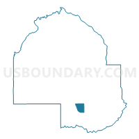
Eden Prairie P-8, Hennepin County, Minnesota
About
Outline

Summary
| Unique Area Identifier | 602495 |
| Name | Eden Prairie P-8 |
| County | Hennepin County |
| State | Minnesota |
| Area (square miles) | 3.95 |
| Land Area (square miles) | 3.59 |
| Water Area (square miles) | 0.36 |
| % of Land Area | 90.91 |
| % of Water Area | 9.09 |
| Latitude of the Internal Point | 44.87675490 |
| Longtitude of the Internal Point | -93.41858090 |
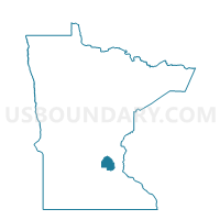
Maps

Graphs
Select a template below for downloading or customizing gragh for Eden Prairie P-8, Hennepin County, Minnesota


Neighbors
Neighoring Voting District (by Name) Neighboring Voting District on the Map
- Bloomington W-3 P-17, Hennepin County, MN
- Eden Prairie P-11, Hennepin County, MN
- Eden Prairie P-12, Hennepin County, MN
- Eden Prairie P-7, Hennepin County, MN
- Edina P-10, Hennepin County, MN
- Edina P-15, Hennepin County, MN
- Edina P-1B, Hennepin County, MN
- Minnetonka W-1 P-A, Hennepin County, MN
- Minnetonka W-1 P-B, Hennepin County, MN
- Minnetonka W-1 P-C, Hennepin County, MN
Top 10 Neighboring County Subdivision (by Population) Neighboring County Subdivision on the Map
- Bloomington city, Hennepin County, MN (82,893)
- Eden Prairie city, Hennepin County, MN (60,797)
- Minnetonka city, Hennepin County, MN (49,734)
- Edina city, Hennepin County, MN (47,941)
Top 10 Neighboring Place (by Population) Neighboring Place on the Map
- Bloomington city, MN (82,893)
- Eden Prairie city, MN (60,797)
- Minnetonka city, MN (49,734)
- Edina city, MN (47,941)
Top 10 Neighboring Unified School District (by Population) Neighboring Unified School District on the Map
- Bloomington Public School District, MN (82,887)
- Hopkins Public School District, MN (61,813)
- Eden Prairie Public School District, MN (57,792)
- Edina Public School District, MN (39,232)
Top 10 Neighboring State Legislative District Lower Chamber (by Population) Neighboring State Legislative District Lower Chamber on the Map
- State House District 42B, MN (43,655)
- State House District 41A, MN (37,836)
- State House District 42A, MN (35,099)
- State House District 41B, MN (34,054)
Top 10 Neighboring State Legislative District Upper Chamber (by Population) Neighboring State Legislative District Upper Chamber on the Map
Top 10 Neighboring 111th Congressional District (by Population) Neighboring 111th Congressional District on the Map
Top 10 Neighboring Census Tract (by Population) Neighboring Census Tract on the Map
- Census Tract 235.02, Hennepin County, MN (5,782)
- Census Tract 260.19, Hennepin County, MN (4,815)
- Census Tract 260.07, Hennepin County, MN (4,534)
- Census Tract 260.20, Hennepin County, MN (4,181)
- Census Tract 261.04, Hennepin County, MN (3,717)
- Census Tract 259.05, Hennepin County, MN (3,696)
- Census Tract 262.08, Hennepin County, MN (3,053)
- Census Tract 239.02, Hennepin County, MN (1,975)
Top 10 Neighboring 5-Digit ZIP Code Tabulation Area (by Population) Neighboring 5-Digit ZIP Code Tabulation Area on the Map
- 55343, MN (23,933)
- 55345, MN (21,147)
- 55346, MN (16,776)
- 55438, MN (16,249)
- 55344, MN (13,952)
- 55436, MN (13,138)
- 55439, MN (8,750)